


- Yokohama-shi cubren la página
- Naka Ward la página de la cima
- Varias palabras (poligloto)
- English
- Public Relations Magazines
- Yokohama de Koho Naka guardan la versión (... 2023)
- 2020
- July - How to prepare for Torrential Rain and Typhoons
Es el texto de aquí.
July - How to prepare for Torrential Rain and Typhoons
Digiere versión de Yokohama de Koho (Relaciones Públicas) la Naka Pupilo edición (Yokohama de información público,....)
Última fecha puesta al día: 2020/7/7
How to prepare for Torrential Rain and Typhoons
Make sure to check the following:
Hazard risks in your area
Torrential rain and typhoons can cause various kinds of disasters, including rivers bursting their banks, flooding of low-lying areas, and landslides. Please check the hazard risks in your area using hazard maps and other sources of information.
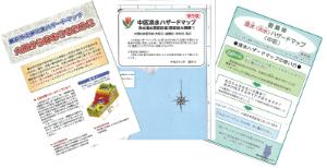
▼City of Yokohama Landslide Disaster Hazard Map (Naka Ward)
This map informs you which areas are at risk of sustaining damage in the event of a landslide due to heavy rain.
▼Naka Ward Flood Hazard Map
This map shows predicted flood areas in the event a river bursts its banks, etc.
▼City of Yokohama Flood (Localized Runoff) Hazard Map (Naka Ward)
This map shows areas in which flooding is predicted from drains and water channels.
▼Waiwai Desastre Prevención Mapa (el sitio externo)
This map provides useful information on disaster prevention, as well as on the dangers of storm and flood damage and earthquakes.
▼Immediate evacuation advisory areas
When landslide disaster hazard information is announced, an evacuation advisory will be issued for these areas. There are 9 of these areas in Naka Ward.
※People living in these areas will be contacted individually by the Ward Office.
You can also pick up a copy of these hazard maps at the Ward Office.
Steps you should take to prepare for torrential rain and typhoons
Q1. Take a look at the hazard maps. Is the area in which you live at risk of any disasters?

Houses on or below a slope

Houses next to a river

Houses next to the sea
A1. Yes ⇒ You live in an area that is at risk of a disaster, so you need to evacuate outside your home.
No ⇒ Make sure to check and keep up to date with disaster information and evacuation information.
Q2. Would it take you a long time to evacuate? (Senior citizens or people with mobility issues, etc.)
A2. Yes ⇒ Evacuate when the warning level reaches 3.
No ⇒ Evacuate when the warning level reaches 4.
When should I evacuate?
The follow chart presents an easy-to-understand guide for each warning level of when to evacuate and what you should do.
| Warning level | What you should do | Evacuation information, etc. |
|---|---|---|
| 5 | It is dangerous to be outside! Use the best means at your disposal to protect your life. | A disaster has occurred. |
| 4 | Everyone should evacuate from the dangerous area. | Evacuation advisory, evacuation order (emergency) |
| 3 | Senior citizens etc. should evacuate from the dangerous area. | Commencement of evacuation preparations/evacuations of senior citizens, evacuation sites open |
| 2 | Check what you need to do when evacuating on hazard maps, etc. | Heavy rain advisory, flood advisory |
| 1 | Pay attention to the latest information and make sure you are ready for disasters. | Early advisories |

Make it a habit to keep up to date with the latest information
Make sure to keep up to date with the latest disaster prevention and weather information, and take early steps to ensure your safety.
Where should I evacuate to?
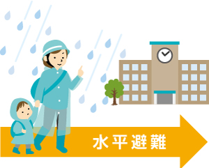
●Evacuate to a safe place.
Los lugares seguros incluyen un sitio de la evacuación, tierra más alta cercana, que la casa de un pariente localizó fuera de las granes áreas de riesgo de desastre y las posibles zonas de diluvio, etc.
●Evacuate to the 2nd floor or above of a sturdy building, or a nearby tall building
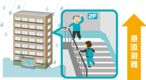
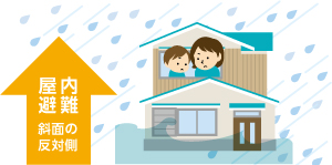
●Evacuate to a safe place inside a building
If evacuating outside would actually put you in more danger, evacuate to the top floor of your home, the side of your home facing away from the slope, etc.
Evacuation sites for storm and flood damage
If a warning level 3 is issued due to storm or flood damage, evacuation sites open up to allow people living in areas next to slopes etc. to evacuate.
- Mugita Seifuso 1-26-1 Mugita-cho
- Yamamoto Elementary School 3-152 Yamamoto-cho
- Otori Elementary School 1-251 Honmoku-cho
- Kamidai Assembly Hall 2-50 Hongo-cho
- Minato Sogo High School 231 Yamashita-cho
※These evacuation sites are different to the evacuation shelters which open up in the event of an earthquake registering 5 upper on the JMA Seismic Intensity Scale.

When going to an evacuation site
Evacuate while it is still light using a safe route, making sure to avoid roads alongside rivers or slopes.
Please bring any necessary items with you to the evacuation site, such as food, water, towels, etc. There are no parking spaces.
※Please ensure to wear a mask when going to an evacuation site to help reduce the risk of coronavirus (COVID-19) infection.
If you are the victim of a disaster
If you are the victim of a natural disaster, please present your disaster certificate (document certifying that you are a disaster victim) to the relevant counter at the Ward Office, etc. In some cases, you may be entitled to the following kinds of aid and support.
・Reduction or exemption of fixed asset tax and municipal/prefectural taxes
・Receipt of relief money for disaster victims, etc.
※You can apply for a disaster certificate at a Ward Office counter (a fire station in the case of fire disasters).
Inquiries: Bosai-tanto (funcionario de prevención de desastre), Naka guardan la oficina TEL.045-224-8112 FAX.045-224-8109
Botones ID: 354-491-349


